
Morocco Map
Last Updated: 2025-06-05
“I would like to visit the most typical places. I am looking for places like Chefchaouen, Marrakech, Fez, Casablanca and the desert. I want to do it in 4 days to enjoy a leisurely trip.”
The preceding text is not a dramatization but a real request and is not, by far, an isolated case. It is understandable that, in the tourism sector we tend to simplify things, pointing out only the most striking destinations. Sometimes travelers think these places are relatively close, especially in a place like Morocco, where geographical reality is deceptively simple.
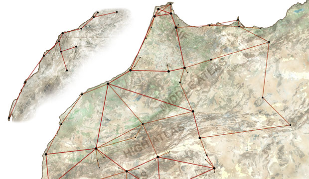
It is the intention of this Morocco Map to resolve this issue. It’s more than simply a road map; it indicates the distances so that the user can, at a glance, be aware of how the country is structured and have a realistic idea and adapt their itinerary according to the time available.

The main features of this map are as follows:
It is intended to be printed on tabloid or A3 paper (it could be done in a smaller format, although it may be somewhat difficult to read). In order to make the most of the format, it is rescaled, so that the most southeastern section, which is a substantially less touristy area, forms a separate smaller section.
Instead of using miles or kilometers, we use hours, since traveling 100 miles or kilometers in Morocco is not comparable to doing so in most developed countries (especially the farther south you go) and can lead to mistaken perception.
A network of main destinations is laid out, followed by others classified as secondary because they are not so popular, you have to go through them to visit other destinations or they are necessary to give an idea of the entire geography of Morocco.
There is also a third network of places somehow connected to a more important destination (for example Ait Ben Haddou with Ouarzazate). It does not mean that you necessarily have to go to the primary destination first to visit one of these other destinations, but this format makes for a more structured map.

Sometimes direct routes are discarded, opting for a more comfortable and complete route and sometimes even faster, although online map applications may indicate otherwise. For example, it is usually recommended to take the national road to go from Chefchaouen to Rabat, but in reality it is shorter if you pass through Asilah and more enjoyable, because the highway goes along the coast.
Times have increased for various reasons, such as general reasons (in Morocco, drivers are required to stop every two hours) or specific reasons (at the entrance to Casablanca there is usually traffic, or getting to Erg Chegaga you have to drive a minimum of 120 minutes to actually reach the site), which most online applications do not take into account.
The minimum time used is half an hour to make it easier to add distances. Of course, it is always preferable to give a greater time than what is expected, so as to have a more flexible itinerary that can accommodate the unexpected.
Finally, we are open to any suggestions. If you feel there is a destination missing, or that there is a distance that is incorrect, please let us know.
Hopefully it will help readers and future travelers to approach the country in an accurate way and understand, that not only does Morocco have another rhythm, but it also deserves for us to adapt to its rhythm.
< Download map of Morocco (A3) >
< Download map of Morocco (Tabloid Size) >
This entry is part of our guide for those who are traveling to Morocco for the first time. If you want to know more, we invite you to read our page with Morocco travel information.